Hurricane Hunter Finds Fred Very Near Tropical Storm Strength
MIAMI (CBSMiami) – A hurricane hunter has found Fred very near tropical storm strength.
As of 11 p.m. Thursday, Fred was 450 miles east-southeast of Key West.
The depression is moving toward the west-northwest near 9 mph and this general motion with a slight increase in forward speed is motion is expected through Friday.
A turn toward the northwest is expected Friday night or Saturday.
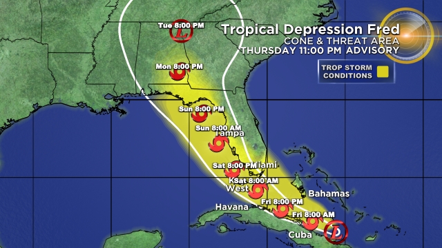
On the forecast track, Fred is expected to move along or just north of eastern and central Cuba tonight and Friday, and be near the Florida Keys and southern Florida on Saturday.
Maximum sustained winds are near 35 mph with higher gusts.
Slow strengthening through Saturday, and Fred could become a tropical storm again later tonight or early Friday.
Fred is expected to be a tropical storm as it nears the Florida Keys and south Florida.
A tropical storm watch is in effect for the Florida Keys west of Ocean Reef to the Dry Tortugas. There is also a tropical storm watch in effect for the southwest coast of Florida from Bonita Beach south and east to Ocean Reef, including Florida Bay.
Some of South Florida remains in the cone. Although the center is forecast to move across the Keys, tropical storm conditions will be possible for all of South Florida as we will be on the east side, or the "dirty side," with all the moisture wrapping around Fred.
Computer models are forecasting the potential for 3 to 5 inches of rain this weekend with isolated higher amounts of 8 inches possible.
The National Weather Service of Miami says there is a marginal risk of excessive rainfall across most of South Florida on Friday and a slight risk of excessive rainfall across the eastern half of South Florida on Saturday due to the potential for heavy rain and flooding. The ground is still somewhat saturated due to the heavy rainfall from our recent storms and any additional heavy rain could lead to flooding across parts of South Florida.
The worst weather is expected late Friday into Saturday. A wet and windy weekend ahead with the potential for tornadoes. The moisture tail of Fred will keep our rain chance high Sunday and possibly into Monday.
Stay safe and stay tuned to CBS4 and CBSMiami.com and download the improved CBSMiami App.