Blog: Meteorologist Craig Setzer's Eye On The Tropics
As I go on my 17th year now forecasting in the tropics, I've learned to look at each tropical, and potential tropical system as something that has many opportunities through its lifetime.
Often a hurricane will start as a line of thunderstorms marching across Africa many weeks before. Sometimes it will start as the leftovers of a cold front in the Atlantic.
And sometimes it just begins as a swirl in the wind that has enough opportunities to grow.
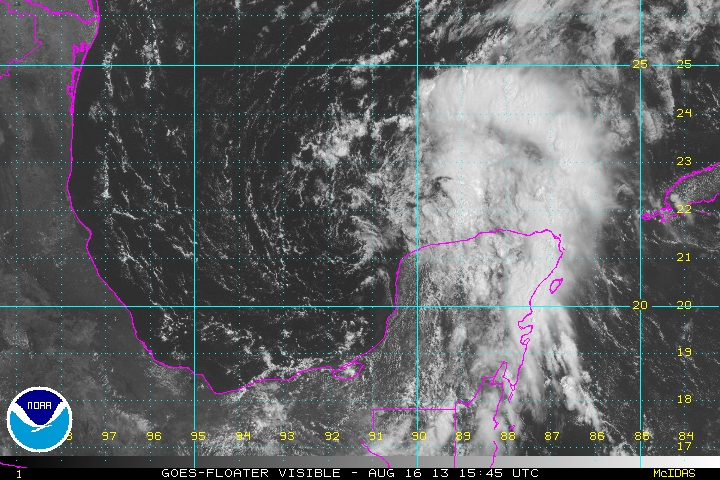
Looking at the swirl in the Gulf of Mexico this Friday morning with origins that stretch back to a cluster of thunderstorms over South America two weeks ago, it's clear it now faces opportunities to grow and potentially impact the US Gulf coastline.
As of Friday, the low level swirl over the southwest Gulf was somewhat displaced from the upper low to its northeast. This is resulting in wind shear over the surface swirl.
Remember, it's this surface swirl we track and identify as the development point for a tropical cyclone.
Besides the wind shear, dry air is also wrapping around the upper low and on top of the swirl. This has the effect of limiting thunderstorm development near the swirl. Without thunderstorms near and over the swirl, it won't develop.
In the next couple of days, the swirl has the opportunity to move away from the upper low and wind shear, develop thunderstorms, and become a tropical depression.
It also has the opportunity to tuck up under the upper low, reducing wind shear, and possibly forming a depression.
But until the low level swirl establishes thunderstorms near or over it, it will likely remain just a swirl of air over the water, possibly missing these opportunities.
We will keep our eyes on the system for the development of those thunderstorms.