Miami Weather: Scattered Showers, Keep Umbrella Handy
MIAMI (CBSMiami) - It was a wet start to the weekend with heavy downpours overnight and early Friday morning.
More than two inches of rain have fallen so far across parts of South Florida and there is some lingering ponding and flooding in spots.
Although we are enjoying a break from the rain now, another round of storms will move in later. Keep your umbrella close and stay weather alert.
The atmosphere remains moist and unstable ahead of a cold front moving across north Florida. The Storm Prediction Center says there is a marginal risk of severe weather on Friday. This means there is an isolated threat for strong to severe storms with the highest potential for heavy rain, lightning, gusty winds, small hail, and only a slight risk of a brief tornado.
Highs will climb to around 80 degrees.
The heating of the day and breaks of sunshine will help fuel storms later on. Forecast models indicate the stronger storms will likely move in late afternoon and evening.
Warm humid air lingers over South Florida and there is the potential for more storms to develop this evening given enough sunshine. Clouds lingered this morning from last night's rain but are beginning to break up this afternoon. This may just be enough to trigger a few storms over the interior that, once they develop, will track northeast back over the metro areas. The best chance to see a gusty storm is in Broward County early this evening.
Any additional rainfall may lead to minor flooding over areas that received the heaviest rain yesterday. In Broward County that was around to just south of Fort Lauderdale near the coast. Stay alert for any severe weather or flood alerts this evening.
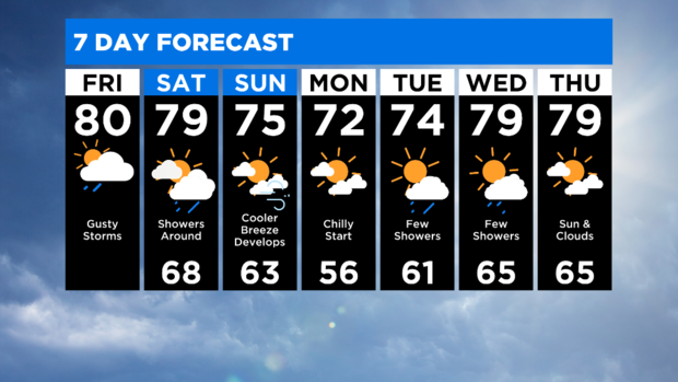
We remain unsettled through Saturday with the potential for scattered showers and highs will remain warm in the upper 70s.
By Sunday the rain chance will be low and we will enjoy drier, mostly sunny weather. Temperatures will begin to drop. Highs will be in the mid 70s on Sunday and lows fall to the upper 50s by Monday morning. Early next week highs will be pleasant in the low 70s. A few showers are possible on Tuesday and Wednesday as we warm right back up to near 80 degrees.