Grace Downgraded To Tropical Depression
MIAMI (CBSMiami) – Grace has been downgraded to a tropical depression, but it's still expected to bring heavy rains to the Dominican Republic and Haiti.
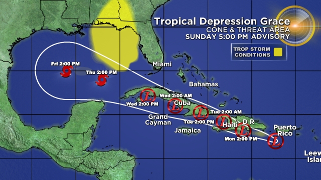
As of the 5 p.m. advisory Sunday, Grace was about 200 miles east-southeast of Santo Domingo, Dominican Republic.
The depression is moving toward the west near 15 mph.
A generally west-northwestward motion is expected over the next few days.
On the forecast track, Grace will move over Hispaniola on Monday, near or over eastern Cuba on Tuesday, and near or over west-central Cuba on Wednesday.
Maximum sustained winds have decreased to near 35 mph with higher gusts.
Little change in strength is forecast during the next 48 hours.
A tropical storm watch is in effect for the entire coast of the Dominican Republic and the entire coast of Haiti.
As for Fred, it regained tropical storm status over the eastern Gulf of Mexico.
It was 190 west-southwest of Tampa Bay as of the 5 p.m. advisory.
Fred is moving toward the north-northwest near 10 mph, and this motion should continue through Sunday night. A turn toward the north is expected on Monday.
On the forecast track, the center of Fred should move across the eastern and northern Gulf of Mexico through Monday, then make landfall in the western Florida Panhandle Monday afternoon or Monday night.
Maximum sustained winds are now near 45 mph with higher gusts. Additional strengthening is expected until landfall. After landfall, Fred is expected to quickly weaken.
Tropical-storm-force winds extend outward up to 90 miles mainly to the east of the center.
There is a tropical storm warning as well as a tropical storm watch in effect for the Florida Panhandle. A storm surge warning is in effect for the coast of Florida from Indian Pass to Yankeetown.