Tracking Elsa: Tropical Storm Elsa A Little Weaker & Moving Slower
MIAMI (CBSMiami) – The latest advisory finds Tropical Storm Elsa a little weaker and moving slower between Haiti and Jamaica.
At 11 p.m., Elsa was about 175 miles east-southeast of Montego Bay, Jamaica.
Elsa was downgraded to tropical storm status with the 11 a.m. Saturday advisory.
Elsa is moving toward the west-northwest near 17 mph. An additional decrease in forward speed is expected Saturday night and on Sunday, followed by a turn toward the northwest Sunday night or Monday.
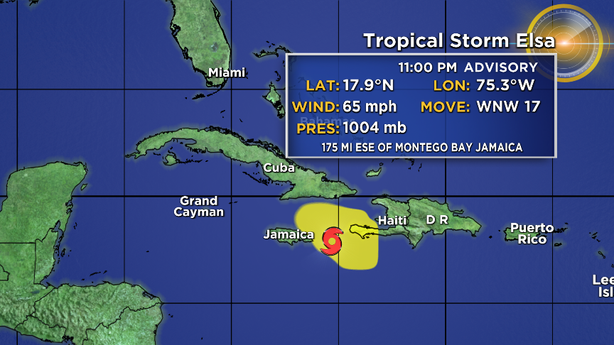
On the forecast track, Elsa will move near the southwestern peninsula of Haiti over the next few hours, and then move near Jamaica and portions of eastern Cuba on Sunday.
By Monday, Elsa is expected to move across central and western Cuba and head toward the Florida Straits.
Elsa is then forecast to move near or over portions of the west coast of Florida on Tuesday.
Maximum sustained winds have decreased to near 65 mph with higher gusts.
Little change in strength is forecast Saturday night, with some slight strengthening possible Sunday afternoon as Elsa approaches the south-central coast of Cuba.
However, gradual weakening is forecast to occur Sunday night and Monday when Elsa will be moving over Cuba.
Tropical-storm-force winds extend outward up to 125 miles from the center.
The Hurricane Warning for the southern portion of Haiti from Port Au Prince to the southern border with the Dominican Republic has been replaced with a Tropical Storm Warning.
SUMMARY OF WATCHES AND WARNINGS IN EFFECT:
A Tropical Storm Warning is in effect for:
- Southern portion of Haiti from Port Au Prince to the southern border with the Dominican Republic
- The Cuban provinces of Camaguey, Granma, Guantanamo, Holguin, Las Tunas, Santiago de Cuba, Ciego de Avila, Sancti Spiritus, Villa Clara, and Cienfuegos
- Jamaica
A Hurricane Watch is in effect for:
- The Cuban provinces of Camaguey, Granma, Guantanamo, Holguin, Las Tunas, and Santiago de Cuba
A Tropical Storm Watch is in effect for:
- Cayman Brac and Little Cayman
- The Cuban provinces of Matanzas, Mayabeque, and Havana
- The Florida Keys from Craig Key westward to the Dry Tortugas
Interests elsewhere in the Cuba, the Cayman Islands, the Florida peninsula and the Florida Keys should monitor the progress of Elsa.
Additional watches and warnings will likely be required Sunday morning.
Hurricane conditions are possible in eastern Cuba on Sunday.
Tropical Storm conditions are expected in the warning area in Haiti tonight and on Jamaica and over eastern and central Cuba on Sunday.
Tropical storm conditions are possible in the watch area in the Cayman Islands Sunday and Sunday night and in western Cuba and the Florida Keys Sunday night and Monday.
STORM SURGE: A storm surge will raise water levels above normal tide levels by as much as the following amounts in areas of onshore flow within the hurricane watch and warning areas:
- Southern coast of Cuba - 3 to 5 feet
- Southern coast of Hispaniola - 2 to 4 feet
The combination of a storm surge and the tide will cause normally dry areas near the coast to be flooded by rising waters moving inland from the shoreline.
The water could reach the following heights above ground somewhere in the indicated areas if the peak surge occurs at the time of high tide:
- Craig Key, FL to Dry Tortugas – 1 to 2 feet
Surge-related flooding depends on the relative timing of the surge and the tidal cycle, and can vary greatly over short distances.
RAINFALL: Across portions of southern Haiti and Jamaica, rainfall of 4 to 8 inches with isolated maximum amounts of 15 inches is expected today into Sunday. This rain may lead to scattered flash flooding and mudslides, some of which may be significant in nature.
Across portions of Cuba Sunday into Monday, rainfall of 5 to 10 inches with isolated maximum amounts of 15 inches is expected. This will result in significant flash flooding and mudslides.
Across the Cayman Islands Sunday into Monday, rainfall of 3 to 5 inches is expected. This rain may lead to scattered flash flooding.
Rainfall from Elsa is likely to impact portions of the Florida Keys and Florida Peninsula early next week. Amounts of 2 to 4 inches with localized maximum amounts up to 6 inches will be possible, which may result in isolated flash, urban, and minor river flooding.
SURF: Swells generated by Elsa will spread westward across the Caribbean Sea through the weekend. These swells are likely to cause life-threatening surf and rip current conditions.