Catastrophic Hurricane Dorian Makes Landfall On Eastern End Of Grand Bahama Islands With 185 MPH Winds
MIAMI (CBSMiami) - Catastrophic Hurricane Dorian makes landfall on the eastern end of Grand Bahama Island as it continues to move very slowly.
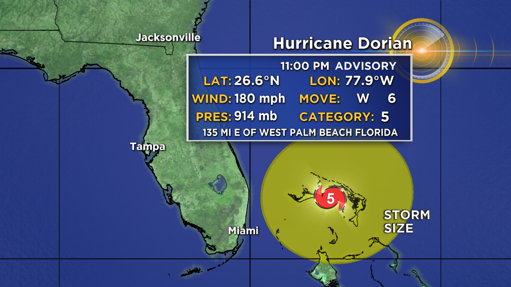
At 11 p.m., the National Hurricane Center said the Category 5 storm had maximum sustained winds of 180 mph, down 5 mph.
Hurricane-force winds extend outward up to 45 miles from the center and tropical-storm-force winds extend outward up to 140 miles.
Dorian is moving toward the west near 6 mph.
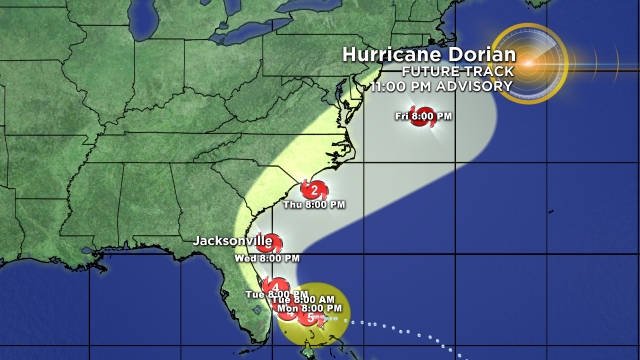
A slower westward to west-northwestward motion is forecast during the next day or so, followed by a gradual turn toward the northwest. On this track, the core of extremely dangerous Hurricane Dorian will continue to pound Great Abaco and Grand Bahama islands overnight and through much of Monday.
The hurricane will move dangerously close to the Florida east coast late Monday through Tuesday night.
Slow weakening is forecast, but fluctuations in intensity could occur couple of days. Regardless, Dorian is expected to remain a powerful hurricane during the next few days.
SUMMARY OF WATCHES AND WARNINGS IN EFFECT:
A Storm Surge Warning is in effect for...
- Lantana to the Volusia/Brevard County Line
A Storm Surge Watch is in effect for...
- North of Deerfield Beach to Lantana
- Volusia/Brevard County Line to the Mouth of the St. Mary's River
A Hurricane Warning is in effect for...
- Northwestern Bahamas excluding Andros Island
- Jupiter Inlet to the Volusia/Brevard County Line
A Hurricane Watch is in effect for...
- Andros Island
- North of Deerfield Beach to Jupiter Inlet
- Volusia/Brevard County Line to the Mouth of the St. Mary's River
A Tropical Storm Warning is in effect for...
- North of Deerfield Beach to Jupiter Inlet
A Tropical Storm Watch is in effect for...
- North of Golden Beach to Deerfield Beach
- Lake Okeechobee
Catastrophic hurricane conditions continue in the Abacos and Grand Bahama Islands. Do not venture out into the eye, as winds will suddenly increase as the eye passes.
Hurricane conditions are expected within the hurricane warning area in Florida by late Monday or Tuesday.
Tropical storm conditions are expected within the tropical storm warning area on Monday and Tuesday and are possible in the tropical storm watch area by Monday night.
STORM SURGE: A life-threatening storm surge will raise water levels by as much as 18 to 23 feet above normal tide levels in areas of onshore winds on the Abaco Islands and Grand Bahama Island. Near the coast, the surge will be accompanied by large and destructive waves.
The combination of a dangerous storm surge and the tide will cause normally dry areas near the coast to be flooded by rising waters moving inland from the shoreline. The water could reach the following heights above ground somewhere in the indicated areas if the peak surge occurs at the time of high tide.
Volusia/Brevard County Line to Jupiter Inlet FL...4 to 7 ft North of Deerfield Beach to Jupiter Inlet FL...2 to 4 ft
The surge will be accompanied by large and destructive waves.
Surge-related flooding depends on the how close the center of Dorian comes to the Florida east coast, and can vary greatly over short distances.
RAINFALL: Dorian is expected to produce the following rainfall totals through late this week:
Northwestern Bahamas...12 to 24 inches, isolated 30 inches.
Coastal Carolinas...5 to 10 inches, isolated 15 inches.
The Atlantic Coast from the Florida peninsula through Georgia...3 to
6 inches, isolated 9 inches.
Southeastern Virginia...2 to 4 inches, isolated 6 inches.
Central Bahamas...2 to 4 inches, isolated 6 inches.
This rainfall may cause life-threatening flash floods.
SURF: Large swells are already affecting east-facing shores of the Bahamas, the Florida east coast, and will spread northward along the southeastern United States coast during the next few days. These swells are likely to cause life-threatening surf and rip current conditions.
- Click here to prepare yourself for an impending storm
- Click here for latest news surrounding hurricanes and the National Hurricane Center
- Click here to see all of the latest maps when a storm forms in the Atlantic
- Click here to download the CBS4 2019 Hurricane Guide (English)
- Click here to download the CBS4 2019 Hurricane Guide (Spanish)
- Download the CBS4 Weather App Here