Hurricane Hunter Plane Confirms Dorian Now A Category 2 Storm
MIAMI (CBSMiami) - A hurricane hunter plane confirmed Dorian is now a Category 2 storm, as it keeps its current track toward Florida.
The storm is expected to grow into a major Category 4 storm, as it moves across the open waters of the Atlantic.
At 11 p.m., the center of the system was about 295 miles east-southeast of the southeastern Bahamas.
It was moving to the northwest at 12 mph with maximum sustained winds of 105 mph.
Hurricane-force winds extend outward up to 25 miles from the center and tropical-storm-force winds extend outward up to 105 miles.
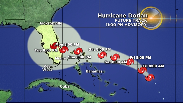
Dorian is forecast to continue moving to the northwest through Friday. A west-northwestward motion is forecast to begin by Friday night and continue into the weekend. On this track, Dorian should move over the Atlantic well east of the southeastern and central Bahamas tonight and on Friday, approach the northwestern Bahamas Saturday, and move near or over portions of the northwest Bahamas on Sunday.
There are no coastal watches or warnings in effect.
Dorian is expected to produce the following rainfall accumulations this weekend into early next week:
The central Bahamas - 1 to 2 inches, isolated 4 inches.
The northwestern Bahamas and coastal sections of the Southeast United States - 4 to 8 inches, isolated 12 inches.
This rainfall may cause life-threatening flash floods.
Swells around the U.S. and British Virgin Islands and Puerto Rico should gradually diminish today. Swells are likely to begin affecting the east-facing shores of the Bahamas and the southeastern United States coast during the next few days. These swells are likely to cause life-threatening surf and rip current conditions.
- Click here to prepare yourself for an impending storm
- Click here for latest news surrounding hurricanes and the National Hurricane Center
- Click here to see all of the latest maps when a storm forms in the Atlantic
- Click here to download the CBS4 2019 Hurricane Guide (English)
- Click here to download the CBS4 2019 Hurricane Guide (Spanish)
- Download the CBS4 Weather App Here