Cold Snap Causes South Florida To Bundle Up
Follow CBSMIAMI.COM: Facebook | Twitter
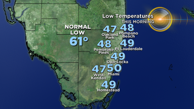
MIAMI (CBSMiami) - Tuesday morning folks across South Florida bundled up with sweaters, jackets and winter weather gear before heading out the door.
It was certainly cold by South Florida standards. Lows fell to mostly mid-to-upper 40s across Broward and Miami-Dade. Our average low this time of year is around 60 degrees. It was also cool across the Keys with lows dropping to the upper 50s overnight.
It will be a beautiful day ahead with high pressure providing dry and quiet weather. With more sunshine in place this afternoon, it will be a little warmer in comparison to yesterday. Highs climb to the upper 60s or right around 70 degrees.
Tuesday night will not be as cold, but there will still be a chill in the air with low-to-mid 50s overnight.
A cold front moves in Tuesday night in Wednesday and highs will be in the upper 60s and low 70s Wednesday afternoon with the chance for spotty showers.
By Thursday lows will be in the upper 50s and the highs will be in the low to mid-70s as winds begin to shift off the Ocean. Some gusty showers possible Thursday. More of an easterly breeze late week will lead to warmer weather.
Friday morning lows will be closer to normal in the low 60s and highs will be seasonable in the upper 70s.
We'll enjoy Super weather this upcoming Super Bowl Weekend with lows in the 60s and highs in the upper 70s on Saturday and Sunday.