Rollercoaster Weather Ride As It Heats Up Today, Ahead Of Cold Front
Follow CBSMIAMI.COM: Facebook | Twitter
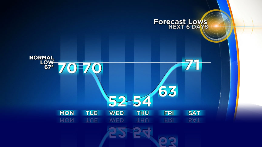
MIAMI (CBSMiami) -- Get ready for a rollercoaster ride of temperatures this week South Florida!
According to CBS4 Meteorologist Lissette Gonzalez, we will be flirting with record heat Monday.
Tuesday will be mild with more clouds and some rain and then a big chill arrives Tuesday night into Wednesday morning.
It has been a foggy start across most of South Florida this Monday morning.
A dense fog advisory was in effect until 9am due to fog reducing visibility to a mile or less in spots.
It has been a mild start with the low 70s in Broward and Miami-Dade and low 80s across the Keys. Today highs climb to the upper 80s with a southwesterly flow in place. Record warmth is possible. It could get as warm as 86 degrees in Miami, the old record is 86 set back in 1979.
Ft. Lauderdale's forecast high is also 86. The old record is 87 degrees set back in 1979.
Key West's forecast high is 84. The old record is 85 set back in 1992.
It will remain mainly dry today with plenty of sunshine. Tonight lows fall to around 70 degrees with the potential for a few showers.
Tuesday highs climb to the upper 70s with more clouds and a better chance of scattered showers.
The cold front moves through Tuesday night and we will see lows fall to the low to mid 50s overnight.
It will be a chilly start for South Florida standards on Wednesday morning.
Highs will struggle to reach 70 degrees with a cooler breeze in place.
Thursday morning will be cool to start with low to mid 50s. Highs in the low to mid 70s.
Friday lows will be back in the 60s.
Highs will be warmer with upper 70s on Friday and we will rebound to the 80s this weekend.