Enjoy The Thrill Of The Chill As Coldest Air Of Week Arrives
Follow CBSMIAMI.COM: Facebook | Twitter
MIAMI (CBSMiami) – Enjoy the thrill of the chill because the coldest air of the week arrived Thursday morning.
Temperatures dropped to the 40s in Broward and Miami-Dade. A few areas closer to the coast were in the low 50s. Some areas are 5 to 10 degrees colder in comparison to Wednesday.
The average low this time of year is 65 degrees which makes these temperatures close to 20 degrees below normal.
It's also cool across the Keys with upper 50s and low 60s. There is plenty of bright sunshine today but it might be hazy in spots.
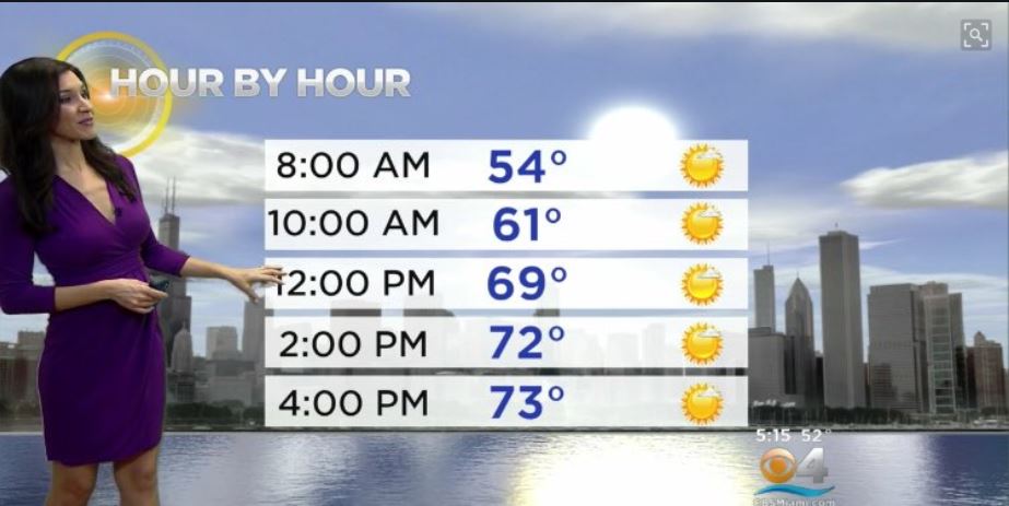
It'll be another dry day with high pressure in control. Highs climb to the low 70s this afternoon. Average high is 80 degrees. Tonight will not be as cold, but still chilly with lows falling to the upper 50s along the coast and low 50s inland.
Friday temperatures will start to rebound with highs in the upper 70s as high pressure shifts to our east and more of an onshore flow moderates our weather. By Saturday morning, we'll see the return of the low 60s and highs will climb to around 80 degrees for St. Patrick's Day.
Sunday our lows will be back to normal with mid 60s and highs will be warmer with low 80s.
It'll be even warmer early next week with lows in the 70s and highs in the mid 80s.
Monday and Tuesday, there is a chance for scattered showers due to another cold front on the way.
By Wednesday of next week, we'll enjoy a cooler start with low 60s and highs in the upper 70s.