Matthew Moving Off Cuba; Hurricane, Tropical Storm Warnings Issued For Parts Of Florida
Follow CBSMIAMI.COM: Facebook | Twitter
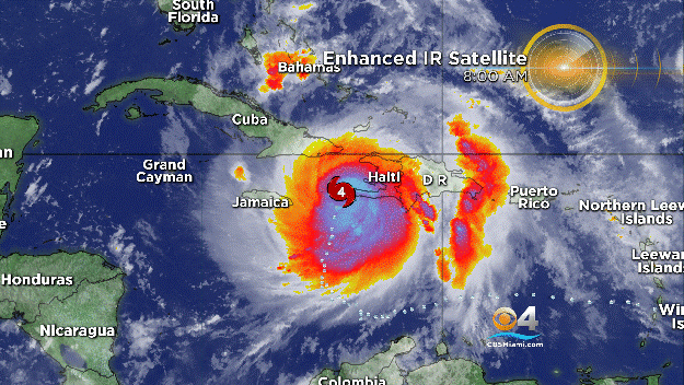
MIAMI (CBSMiami) – The eye of powerful Hurricane Matthew is moving off of the northeastern coast of Cuba, while hurricane and tropical storm warnings have been issued for parts of Florida.
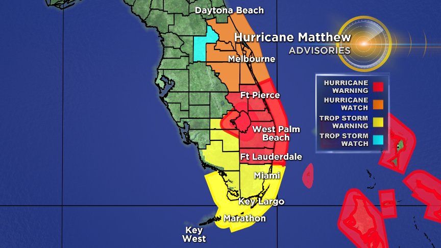
The National Hurricane Center issued a Hurricane Warning for Broward County and areas north. Tropical Storm Warnings have been issued for Miami-Dade County and the middle and upper Florida Keys.
At 11 p.m. the center of the eye of the Category 4 system was 55 miles east-northeast of Guantanamo, Cuba.
Matthew's maximum sustained winds were down to 130 mph. Hurricane-force winds extend outward up to 45 miles from the center and tropical-storm-force winds extend outward up to 175 miles.
SUMMARY OF WATCHES AND WARNINGS IN EFFECT:
A Hurricane Warning is in effect for:
- Haiti
- Cuban provinces of Guantanamo, Santiago de Cuba, Holguin, Granma, and Las Tunas
- Southeastern Bahamas, including the Inaguas, Mayaguana, Acklins, Crooked Island, Long Cay, and Ragged Island
- Central Bahamas, including Long Island, Exuma, Rum Cay, San Salvador, and Cat Island
- Northwestern Bahamas, including the Abacos, Andros Island, Berry Islands, Bimini, Eleuthera, Grand Bahama Island, and New Providence
- North of Golden Beach to Sebastian Inlet
- Lake Okeechobee
A Hurricane Watch is in effect for:
- Cuban province of Camaguey
- North of Sebastian Inlet to the Flagler/Volusia county line
A Tropical Storm Warning is in effect for:
- Dominican Republic from Barahona westward to the border with Haiti
- Turks and Caicos Islands
- Chokoloskee to Golden Beach
- Florida Keys from Seven Mile Bridge eastward
- Florida Bay
A Tropical Storm Watch is in effect for:
- Dominican Republic from Puerto Plata westward to the border with Haiti
Interests elsewhere in the Florida Peninsula and the Florida Keys should monitor the progress of Matthew.
Matthew is moving toward the north near 8 mph, and this general motion is expected to continue Tuesday night.
A turn toward the north-northwest is expected on Wednesday, followed by a northwest turn Wednesday night.
Matthew will be moving through the Bahamas through Thursday, and is expected to be very near the east coast of Florida by Thursday evening.
Some fluctuations in intensity are possible during the next couple of days, but Matthew is expected to remain a powerful hurricane through at least Thursday night.
Matthew is expected to produce total rainfall amounts in the following areas:
- Southern Haiti and southwestern Dominican Republic...15 to 25 inches, isolated 40 inches
- Eastern Cuba and northwestern Haiti...8 to 12 inches, isolated 20 inches
- Eastern Jamaica...4 to 6 inches, isolated 10 inches
- The Bahamas...8 to 12 inches, isolated 15 inches
- Turks and Caicos Islands...2 to 5 inches, isolated 8 inches
- Northeastern Haiti and the Northern Dominican Republic...1 to 3 inches, isolated 5 inches
- Western Jamaica...1 to 2 inches, isolated 3 inches
- Upper Florida Keys northward to coastal east-central Florida....4 to 7 inches, isolated 10 inches
- Middle to Lower Florida Keys....1 to 3 inches, isolated 5 inches
Life-threatening flash floods and mudslides are likely from this rainfall in southern and northwestern Haiti, the southwestern Dominican Republic, and eastern Cuba.
The combination of a dangerous storm surge and large and destructive waves could raise water levels by as much as the following amounts above normal tide levels:.
- Southern Coast of Cuba east of Cabo Cruz...7 to 11 feet
- South Coast of Haiti...7 to 10 feet
- Northern Coast of Cuba east of Camaguey...4 to 6 feet
- Jamaica...2 to 4 feet
- Gulf of Gonave in Haiti...3 to 5 feet
- Southern coast of the Dominican Republic...1 to 3 feet
- The Bahamas...10 to 15 feet
The water could reach the following heights above ground if the peak surge occurs at the time of high tide...
- North Palm Beach to the Flagler/Volusia county line...3 to 5 ft
Swells generated by Matthew will continue to affect portions of the coasts of Hispaniola, Jamaica, eastern Cuba, and the Caribbean coastline of Central America during the next few days. Swells from Matthew will begin affecting portions of the Bahamas on Tuesday. These swells are likely to cause life- threatening surf and rip current conditions.
- Click here for ways to prepare yourself for an impending storm from the CBSMiami.com Hurricane Preps page
- Click here for the latest news surrounding hurricanes and the National Hurricane Center
- Click here to see all of the latest maps when a storm forms in the Atlantic
- Click here to download the CBS4 2016 Hurricane Guide (English)
- Click here to download the CBS4 2016 Hurricane Guide (Spanish)
- Click here for Live Weather Blog
- Download CBS4 Weather App Here