Matthew Moving Away From Bahamas, Onto East Coast
Follow CBSMIAMI.COM: Facebook | Twitter
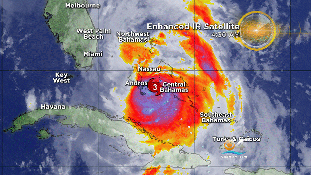
MIAMI (CBSMiami) – The eye of extremely dangerous Hurricane Matthew is moving away from the Bahamas and toward the east coast of Florida.
At 11 p.m. the center of the Category 4 hurricane was about 50 miles north-northwest of Grand Bahama Island and 125 miles east of Cape Canaveral.
The system's maximum sustained winds were 130 mph as it moved to the northwest at 13 mph. Hurricane-force winds extend outward up to 60 miles from the center and tropical-storm-force winds extend outward up to 185 miles.
A turn toward the north-northwest is expected on Friday, and a turn toward the north expected Friday night or Saturday.
On the forecast track, the center of Matthew will be moving near or over the east coast of the Florida peninsula through Friday night, and near or over the coasts of Georgia and South Carolina on Saturday.
SUMMARY OF WATCHES AND WARNINGS IN EFFECT:
A Hurricane Warning is in effect for:
- Northwestern Bahamas, including the Abacos, Andros Island, Berry Islands, Bimini, Eleuthera, Grand Bahama Island, and New Providence
- Boca Raton to South Santee River
- Lake Okeechobee
A Tropical Storm Warning is in effect for:
- Ocean Reef to south of Boca Raton
- Anclote River to Suwannee River
- North of South Santee River to Surf City
A Tropical Storm Watch is in effect for:
- Englewood to Anclote River
Interests elsewhere in the Florida Peninsula, the Florida Keys, and in the Carolinas should monitor the progress of Matthew.
STORM SURGE
The combination of a dangerous storm surge and large and destructive waves could raise water levels by as much as the following amounts above normal tide levels:
- Northwestern Bahamas...10 to 15 feet
The water could reach the following heights above ground if the peak surge occurs at the time of high tide:
- Sebastian Inlet to Edisto Beach, including portions of the St.Johns River...7 to 11 ft
- Edisto Beach to South Santee River...4 to 6 ft
- Deerfield Beach to Sebastian Inlet...4 to 6 ft
- Virginia Key to Deerfield Beach...1 to 3 ft
Surge-related flooding depends on the relative timing of the surge and the tidal cycle and can vary greatly over short distances.
Large waves generated by Matthew will cause water rises to occur well in advance of and well away from the track of the center.
The combination of a dangerous storm surge and the tide will cause normally dry areas near the coast to be flooded by rising waters moving inland from the shoreline. There is a danger of life- threatening inundation during the next 36 hours along the Florida east coast, the Georgia coast, and the South Carolina coast from Deerfield Beach, Florida to Edisto Beach, South Carolina. There is the possibility of life-threatening inundation during the next 48 hours from north of Edisto Beach to South Santee River, South Carolina.
RAINFALL
Matthew is expected to produce total rainfall amounts in the following areas:
- Coastal eastern Florida, Georgia, and South Carolina....4 to
8 inches, isolated 12 inches - The Florida Keys...1 to 3 inches, isolated 5 inches
- The Bahamas...8 to 12 inches, isolated totals of 15 inches
- Eastern Cuba...additional 2 to 4 inches, isolated storm-totals of 20 inches
- Central Cuba...additional 2 to 4 inches, isolated storm-totals of 8 inches
Life-threatening flash floods and mudslides are likely in central and eastern Cuba.
SURF
Swells generated by Matthew will continue to affect portions of the north coast of Cuba and the Bahamas during the next few days and will spread northward along the east coast of Florida and the southeast U.S. coast through the weekend. These swells will likely cause life-threatening surf and rip current conditions.
- Click here for ways to prepare yourself for an impending storm from the CBSMiami.com Hurricane Preps page
- Click here for the latest news surrounding hurricanes and the National Hurricane Center
- Click here to see all of the latest maps when a storm forms in the Atlantic
- Click here to download the CBS4 2016 Hurricane Guide (English)
- Click here to download the CBS4 2016 Hurricane Guide (Spanish)
- Click here for Live Weather Blog
- Download CBS4 Weather App Here