Tropical Storm Colin About To Make Landfall In Florida's Big Bend
Follow CBSMIAMI.COM: Facebook | Twitter
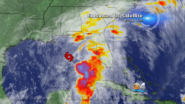
MIAMI (CBSMiami) – Tropical Storm Colin is about to make landfall in the Florida Big Bend area.
At 10:30 p.m., the center of the system was about 70 miles east of Apalachicola and about 65 miles northwest of Cedar Key.
It was moving to the northeast at 23 mph with maximum sustained winds of 50 mph. Tropical-storm-force winds extend outward up to 230 miles from the center.
A Tropical Storm Warning is in effect for Indian Pass to Englewood, and from the Sebastian Inlet, Florida to Oregon Inlet, North Carolina.
Colin is forecast to take northeastward motion at a faster forward speed over the next 48 hours.
On the forecast track, the center of Colin will move onshore in the Florida Big Bend area shortly, then move across northern Florida and southeastern Georgia through early Tuesday morning, and move near or over the southeastern coast of the United States Tuesday.
However, it's important to note that the strongest winds and heaviest rains are well removed from the center.
Some strengthening is forecast after Colin moves into the Atlantic on Tuesday.
Western to northern Florida, southeast Georgia and coastal areas of the Carolinas could see up to 3 to 6 inches of rain through Tuesday. Some isolated areas could see up to 10 inches of rain.
The combination of a storm surge and the tide will cause normally dry areas near the coast to be flooded by rising waters.
The water could reach 1 to 3 feet from Indian Pass to Tampa Bay and 1 to 2 feet from Tampa Bay south to Florida Bay if the peak surge occurs at the time of high tide.
Localized coastal flooding and dangerous surf are possible along the Atlantic coast from Florida to North Carolina within the tropical storm warning area.
Tropical storm conditions will continue across portions of the warning area along the west coast of the Florida peninsula for the next several hours.
Tropical storm conditions have likely begun over portions of the warning area along the Atlantic coast of Florida, and these conditions will spread northward and northeastward over the remainder of the warning area overnight and on Tuesday.
A tornado or two will remain possible across parts of central and northeast Florida early tonight, and perhaps near coastal areas of Georgia and the Carolinas overnight.
- Click here for ways to prepare yourself for an impending storm from the CBSMiami.com Hurricane Preps page
- Click here for the latest news surrounding hurricanes and the National Hurricane Center
- Click here to see all of the latest maps when a storm forms in the Atlantic
- Click here to download the CBS4 2016 Hurricane Guide (English)
- Click here to download the CBS4 2016 Hurricane Guide (Spanish)
- Click here for Live Weather Blog
- Download CBS4 Weather App Here