Joaquin Becomes Cat. 3 Hurricane
Follow CBSMIAMI.COM: Facebook | Twitter
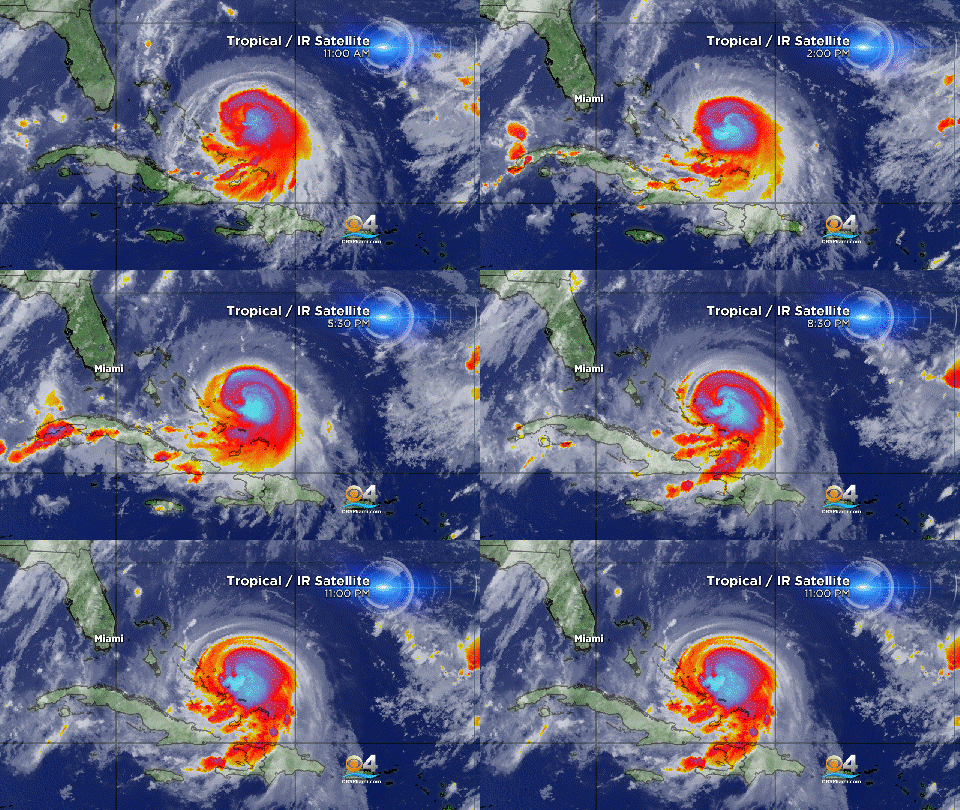
MIAMI (CBSMiami) - Hurricane Joaquin is now a Category 3 hurricane as it moves toward the Central Bahamas.
At 11 p.m. the center of the system was about 90 miles east of the Salvador and 170 miles east of the Central Bahamas.
Maximum sustained winds have increased to near 115 mph with higher gusts. Additional strengthening is forecast during the next day or so. Some fluctuations in intensity are possible Thursday night and Friday.
Hurricane force winds extend outward up to 35 miles from the center and tropical storm force winds extend outward up to 140 miles.
Joaquin is moving toward the southwest near 6 mph and this general motion is expected to continue over the next 24 hours.
A turn toward the northwest and north is forecast Thursday night or Friday. The center of Joaquin is expected to move near or over portions of the central Bahamas overnight and Thursday, and be near or over portions of the Northwestern Bahamas Thursday night or Friday.
A hurricane warning is in effect for the Central Bahamas including Cat Island, the Exumas, Long Island, Rum Cay, San Salvador, Northwestern Bahamas including the Abacos, Berry Islands, Eleuthera, Grand Bahama Island and New Providence, but excluding Andros Island and Bimini.
A hurricane watch is in effect for Bimini and Andros Island.
A tropical storm warning is in effect for Southeastern Bahamas including the Acklins, Crooked Island, Long Cay, the Inaguas, Mayaguana and the Ragged Islands, but excluding the Turks and Caicos Islands.
A hurricane warning means that hurricane conditions are expected somewhere within the warning area. Preparations to protect life and property should be rushed to completion.
A dangerous storm surge will raise water levels by as much as 5 to 8 feet above normal tide levels in the Central Bahamas in areas of onshore flow. A storm surge of 2 to 4 feet above normal tide levels is expected in the Northwest Bahamas within the Hurricane Warning area, and 1 to 2 feet is expected in the Southeast Bahamas. Near the coast, the surge will be accompanied by large and dangerous waves.
Joaquin is expected to produce total rain accumulations of 10 to 15 inches over the central Bahamas and 5 to 10 inches over the northwestern Bahamas and southeastern Bahamas. Isolated maximum amounts of 20 inches are possible in the central Bahamas. This rainfall could result in life-threatening flash floods.
Swells generated by Joaquin will affect portions of the Bahamas during the next few days, and will begin to affect portions of the southeastern coast of the United States by Thursday. These swells are likely to cause life-threatening surf and rip current conditions. Please consult products from your local weather office.
- Click here for ways to prepare yourself for an impending storm from the CBSMiami.com Hurricane Preps page
- Click here for the latest news surrounding hurricanes and the National Hurricane Center
- Click here to see all of the latest maps when a storm forms in the Atlantic
- Click here to download the CBS4 2015 Hurricane Guide (English)
- Click here to download the CBS4 2015 Hurricane Guide (Spanish)


